
The El Niño-Southern Oscillation cycle directly shapes where fish hold, how bait concentrates, and when your seasonal timing should shift. Understanding which ENSO phase you are fishing in, and combining that knowledge with real-time satellite tools, changes how you plan offshore trips and structure your presentations.
Understanding El Niño and La Niña: Reading the Ocean for Smarter Fishing
The ocean is never static. Water temperature, current direction, bait location, and fish behavior shift constantly, and behind many of those shifts is a climate cycle most anglers have heard of but few fully understand. El Niño and La Niña are not just weather terms on the evening news. They are ocean-atmosphere events that reorganize the very conditions your target species depend on, from the depth of the thermocline to the density of the baitfish schools that put marlin, tuna, mahi-mahi, and wahoo in your spread. If you can read the cycle, you can stop guessing and start positioning.
Understanding how ENSO works will not tell you exactly where to drop baits on a given morning. What it will do is help you understand why the bite has been off, why certain species have pushed deeper or shifted offshore, and where the productive water is most likely to be holding during any given season. Pair that knowledge with the real-time oceanographic tools available today, and you have a genuine edge.
What Is ENSO, and Why Should Anglers Care?
ENSO stands for El Niño-Southern Oscillation. It describes a three-phase climate cycle driven by shifts in sea surface temperature and atmospheric pressure across the tropical Pacific Ocean. The three phases are El Niño (warm), La Niña (cool), and ENSO-Neutral. The neutral phase is not a transition; it is a recognized state that can persist for a year or more, and it has its own distinct fishing character.
El Niño events typically develop and mature over nine to twelve months. La Niña is different. La Niña events routinely last one to three years, with more than half of all La Niña events persisting for two years or longer. The 2020 through 2023 La Niña lasted three consecutive years. That duration matters enormously for fishing planning. A strong La Niña is not a one-season event. It is a multi-year shift in ocean conditions that will shape where your target species show up, how the bait concentrates, and how your seasonal timing should adjust.
How Does El Niño Actually Work?
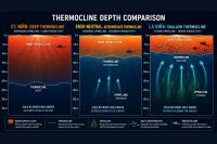
The thermocline is the boundary layer in the ocean where warm surface water meets cold deep water. Above the thermocline, water is warmer and lighter. Below it, water is cold, dense, and nutrient-rich. The thermocline is not fixed; it rises and falls with conditions, and ENSO is its most powerful long-range regulator.
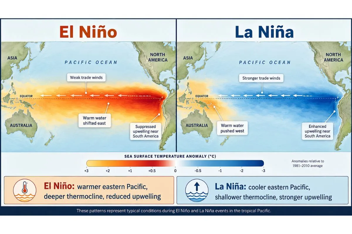
Under normal conditions, the trade winds blow westward across the tropical Pacific, piling warm surface water near Asia and Australia. As that warm water moves west, cold water upwells along the coast of South America to replace it, pulling nutrients toward the surface and fueling phytoplankton growth. That phytoplankton feeds zooplankton, which feeds baitfish, which feeds the gamefish you are after. The food chain starts at the surface of the water column and only works when nutrients can reach light.
During El Niño, those trade winds weaken and sometimes reverse. A massive pulse of warm water, called a Kelvin wave, travels eastward along the underside of the thermocline from the western Pacific. When it arrives, it depresses the thermocline deeper in the eastern Pacific and shuts down upwelling. Nutrients stay locked in the deep. Phytoplankton crash, baitfish thin out, and predators either go hungry or relocate. The suppressed upwelling effect does not fix itself overnight. Strong El Niño events can fundamentally disrupt the food base for an entire season or longer.
La Niña runs the opposite direction. Trade winds strengthen, warm water pushes further west, upwelling intensifies, and cold nutrient-rich water floods the surface layer of the eastern Pacific. Phytoplankton blooms. Baitfish explode. Predators concentrate.
What El Niño Means for Atlantic and Gulf Anglers
Does El Niño affect fishing in the Gulf of Mexico and Atlantic?
Yes, but the mechanism is atmospheric rather than oceanic. El Niño does not directly warm Gulf of Mexico or Atlantic waters the way it does in the eastern Pacific. Its influence arrives through changes in the jet stream, precipitation patterns, and most critically, hurricane activity.
El Niño increases vertical wind shear over the Atlantic basin. That wind shear disrupts tropical cyclone formation. In practical terms, El Niño years typically produce fewer and weaker Atlantic hurricanes. For offshore anglers, this is significant. A quieter hurricane season means more fishable days during the late summer and fall peak for blue marlin, yellowfin tuna, and wahoo in the Atlantic and Gulf. Tournament schedules are less likely to get disrupted. Weather windows open up more frequently through August, September, and October.
El Niño winters in the Gulf region and Southeast tend to be wetter than normal. The jet stream shifts southward, driving more storm activity and precipitation across the southern tier of the United States. That increased rainfall can cool and freshen nearshore and estuarine waters faster than normal, compressing the thermal window for cold-sensitive inshore species. Tarpon, snook, and redfish pushed by heavy rain events into cold-stressed inshore habitats will vacate flats and creek mouths for deeper refugia earlier in the fall than anglers may expect based on historical timing.
- Expect a more active offshore window through late summer and fall due to reduced hurricane disruption
- Watch for accelerated thermal cooling of inshore flats through the fall and winter
- Cold-sensitive inshore species may move earlier and deeper than normal
- Spring can arrive later inshore if wet, cooler El Niño winters persist
What La Niña Means for Atlantic and Gulf Anglers
How does La Niña change fishing on the East Coast and Gulf?
La Niña reduces wind shear over the Atlantic, creating a more favorable environment for tropical cyclone development. La Niña years historically produce more active Atlantic hurricane seasons. For offshore anglers, this compresses fishable windows during the late summer and early fall and raises the probability of season-disrupting storms. Tournament planning, charter scheduling, and multi-day offshore trips all carry greater weather risk during active La Niña hurricane seasons.
The winter pattern inverts. La Niña winters in the South tend to be drier and warmer than normal. Cold fronts are less persistent. That extended warmth benefits inshore fishing significantly. Tarpon, snook, redfish, and other warm-water nearshore species can remain active well into December and sometimes into January. Anglers who track seasonal patterns closely know that a La Niña winter often extends productive inshore action by four to six weeks beyond what El Niño or neutral winters typically allow.
Offshore, La Niña's warm, dry southern winters keep surface temperatures elevated longer along the Gulf Stream edge and in Caribbean waters, holding pelagic species in familiar territory rather than pushing them offshore or deeper as falling temperatures would do in a normal winter. Mahi-mahi, wahoo, and sailfish action along temperature breaks and weed lines can remain consistent later in the season during La Niña.
- Plan around a more active hurricane season; build weather contingency into offshore scheduling
- Extend inshore fishing plans for warm-water species through late fall and into winter
- Offshore pelagic action along the Gulf Stream and Caribbean edges may hold later in the season
- Cold fronts are less aggressive, which means fewer recovery periods after weather disruptions
How Fish Actually Respond to ENSO Conditions
How does El Niño affect marlin, tuna, and wahoo?
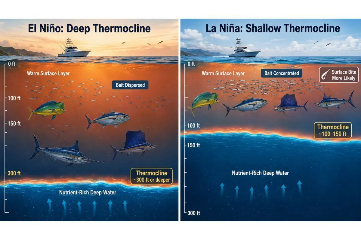
The thermocline is the key variable. During El Niño, the deeper thermocline allows fish and bait to spread through a larger portion of the water column. Surface-oriented schooling fish disperse. Concentrations become harder to find. The bait that holds pelagic predators near the surface gets diffused.
For blue marlin, this typically means fish go deeper and become harder to raise on surface baits and teasers. When the thermocline pushes 300 feet deep or more, marlin follow the bait down rather than herding it toward the surface. Spreads that normally produce reliable bites need adjustment.
For yellowfin and bigeye tuna, the picture is more nuanced. While El Niño does shift tropical tuna distribution westward in the Pacific, its effect on tuna catch rates in Atlantic and Gulf longline-depth fisheries is not simply negative. Research has shown that bigeye and yellowfin CPUE in deeper gear fisheries can actually improve during and after El Niño events, likely because El Niño conditions enhance recruitment and alter the depth at which fish concentrate relative to gear. The fish go deeper, but they can be more accessible to properly fished deeper presentations when you are targeting them at the right depth.
For mahi-mahi, the thermocline depth matters directly. Mahi are shallow-water pelagics that concentrate under weedlines, current edges, and floating structure in the top 100 feet. A deeper thermocline during El Niño means their prey disperses further down, pulling mahi off the weedline and making them harder to find and less aggressive on the surface.
Tactical Adjustments Based on ENSO Phase
How should anglers adjust their trolling spread during El Niño?
When the thermocline is deep and fish are spread through more of the water column, surface trolling spreads become less efficient. The key adjustments:
- Run deep-diving lures and skirted baits in the 30- to 50-foot zone rather than relying on flat lines and short riggers
- Increase the use of planer rigs to push baits down to where bait and fish are actually holding
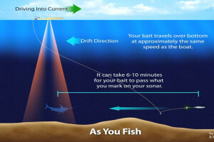
- Consider downriggers for tuna when acoustic returns show fish holding at depth but not coming to the surface
- Troll slower, not faster, when fish are deep and lethargic in warmer, less productive surface water
- Spread baits further behind the boat to reduce noise impact in clear, warm El Niño water
- Standard surface trolling spreads become more productive when the thermocline is shallow
- Short and medium rigger positions run a higher percentage of the productive zone
- Faster trolling speeds can be effective as bait and predators are both more active in cooler, oxygenated water
- Topwater poppers and stick baits on spinning gear become viable options for mahi and smaller tunas when bait is stacked at the surface
For a detailed breakdown of how working captains structure trolling spreads for offshore pelagics in varying conditions, the In The Spread blue marlin trolling course series covers spread construction and speed adjustments with precision.
How does the thermocline depth change live bait and chunk fishing tactics?
When the thermocline is deep during El Niño, kite fishing and live bait presentations on the surface become less effective at drawing fish up from below. The preferred adjustment is to fish baits at the depth where the temperature break actually occurs rather than above it. For chunking tuna, let the chunk line sink deeper before initiating a slow retrieval. For live baits on swordfish or bigeye tuna at depth, target the thermocline zone rather than fishing above it.
Conditions Based Fishing Courses on Blue Marlin and Swordfish
Real-Time Tools Every ENSO-Aware Angler Should Monitor
Which ocean forecasting tools should offshore anglers use?
The science of ENSO only translates into better fishing through real-time ocean intelligence. The following tools are essential, and each one becomes more valuable in the context of knowing which ENSO phase you are in.
NOAA Climate Prediction Center (CPC) ENSO Outlook The CPC publishes monthly ENSO status reports and seasonal probability forecasts at climate.prediction.center. This is where you find official El Niño and La Niña declarations, SST anomaly readings in the Niño 3.4 monitoring region, and probabilistic outlooks for the coming season. Check this at the start of each season and once a month through your primary fishing months.
NOAA Niño 3.4 SST Anomaly Tracker The Niño 3.4 region, a box in the central equatorial Pacific between 5°N and 5°S, 170°W to 120°W, is the primary benchmark for ENSO intensity. NOAA publishes current and historical anomaly charts here. Knowing whether you are looking at a +0.5°C moderate El Niño or a +2.5°C strong event tells you how aggressively to adjust your expectations.
NOAA GODAS Subsurface Temperature Anomaly Charts This is the Kelvin wave tracker. GODAS (Global Ocean Data Assimilation System) publishes equatorial Pacific subsurface temperature anomaly cross-sections that show where warm or cold water is building below the surface. A large mass of warm water moving eastward below the thermocline is a Kelvin wave in progress, a developing El Niño signal months before it shows up on SST charts. Checking this once a month gives you lead time that most anglers never have.
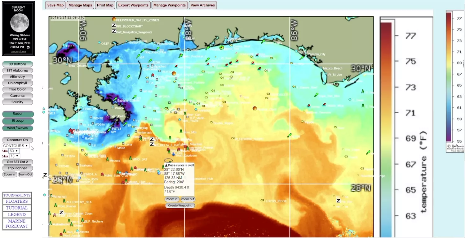
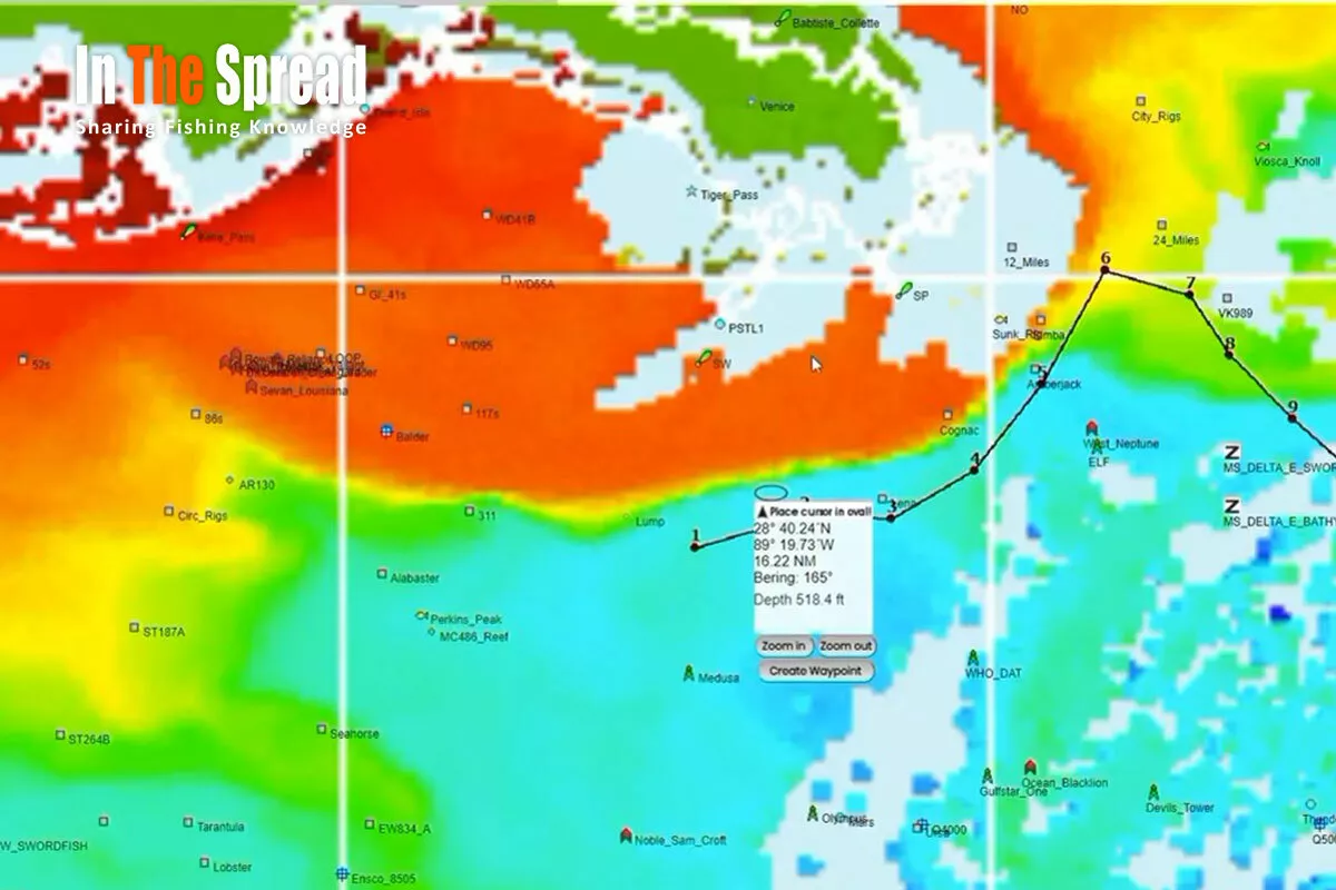
Hilton's Realtime Navigator Hilton's is the gold standard for satellite oceanographic intelligence for offshore fishing in the Atlantic and Gulf. Their charts integrate sea surface temperature, chlorophyll concentration, sea surface height anomaly, and current analysis into a fishing-specific overlay. In the context of ENSO, Hilton's SST charts help you see exactly where the temperature breaks, weed lines, and current edges are holding relative to what ENSO suggests they should be doing. The subscription is one of the best investments an offshore angler can make.
ROFFS (Roffer's Ocean Fishing Forecasting Service) ROFFS provides expert-interpreted satellite fishing forecasts specifically for offshore anglers. Where Hilton's gives you the raw satellite data, ROFFS layers professional oceanographic interpretation on top of it. During ENSO-influenced seasons when conditions are less predictable, that interpreted guidance is especially valuable. ROFFS covers the Atlantic, Gulf, and Caribbean comprehensively.
Chlorophyll Concentration Charts (NASA Worldview or CoastWatch) Chlorophyll concentration is a direct proxy for phytoplankton, and phytoplankton is the base of the food chain. During El Niño, you will see chlorophyll-depleted (deep blue, nutrient-poor) water pushing inshore as upwelling fails. During La Niña, green, chlorophyll-rich upwelling water signals productive bait zones. NASA's Worldview platform and NOAA CoastWatch both provide free near-real-time chlorophyll imagery.
El Niño and La Niña in the Eastern Pacific: A Brief Picture
For context, the eastern Pacific is where ENSO's fishing effects are most dramatic and most directly felt. During El Niño, tropical species including dorado, wahoo, striped marlin, blue marlin, yellowfin tuna, and even black marlin extend their range northward into California, Oregon, and Washington waters, latitudes where they rarely appear in normal years. The Southern California Bight can fish like a tropical destination during a strong warm event.
The tradeoff is that the cold upwelling productivity that normally sustains the eastern Pacific's extraordinary bait base collapses. Squid, anchovies, and sardines that form the foundation of Pacific pelagic food webs thin out as the thermocline drops and nutrients stay locked in the deep.
Frequently Asked Questions About ENSO and Fishing
How long does El Niño last, and how long does La Niña last?
El Niño events typically develop and run their course over nine to twelve months. La Niña events routinely last one to three years. More than half of all La Niña events extend beyond two years. If you are fishing in a La Niña environment, plan on multi-season adjustments, not just one.
Does El Niño help or hurt fishing?
It depends entirely on where you fish and what you target. El Niño suppresses bait and upwelling productivity in the eastern Pacific but can extend tropical species into higher latitudes and reduce Atlantic hurricane season activity. For Gulf and Atlantic offshore anglers, a quiet El Niño hurricane season can mean dramatically better fall fishing access. For eastern Pacific anglers fishing cold-water bait-dependent species, El Niño is typically difficult.
How do I know which ENSO phase we are in right now?
Check NOAA's Climate Prediction Center ENSO outlook monthly. The CPC issues official ENSO status updates with current SST anomaly readings and seasonal probability forecasts. A Niño 3.4 anomaly above +0.5°C for five consecutive overlapping three-month periods constitutes an official El Niño. Below -0.5°C for the same duration is La Niña.
Can ENSO forecasters predict the type of El Niño in advance?
Not reliably. Forecasters can often project that an El Niño or La Niña is developing several months in advance, but there is currently very little ability to predict which type of event will occur. Since different ENSO types produce meaningfully different fishery outcomes, treat seasonal ENSO forecasts as directional guidance and continue relying on real-time satellite tools to find actual conditions on the water.
Does ENSO affect Caribbean fishing?
Yes. ENSO affects Caribbean fisheries primarily through hurricane season intensity, winter weather patterns, and sea surface temperature anomalies along the current boundaries and upwelling zones that concentrate baitfish and pelagic gamefish. La Niña's increased hurricane activity compresses productive fall offshore windows. El Niño's quieter hurricane seasons often extend the accessible offshore fishing calendar.
Should I change my bait selection based on ENSO phase?
Not directly by bait species, but by presentation depth and zone. When El Niño deepens the thermocline, the bait species your target gamefish are following are holding deeper. Adjust your presentation to match that depth rather than fishing where the bait was last season. Real-time chlorophyll and SST data will tell you where bait is actually concentrated on any given day, regardless of what the climate index is doing.
Putting It All Together: A Seasonal ENSO Checklist for Offshore Anglers
Most anglers check weather before a trip. The anglers who consistently find fish also check the ocean at a seasonal and annual level. Here is a practical workflow:
- Check the NOAA CPC ENSO status page. Note the current phase and the projected phase for the coming months.
- Pull a GODAS subsurface temperature anomaly chart. Note whether a Kelvin wave is moving eastward, an early El Niño signal, or whether cold subsurface anomalies suggest a developing La Niña.
- Check the current PDO phase if you fish the Pacific or want context for long-range North Atlantic productivity.
Monthly during your fishing season:
- Update your ENSO phase assessment from CPC.
- Review the Niño 3.4 SST anomaly trend: is the event intensifying, weakening, or tracking neutral?
- Cross-reference with Hilton's or ROFFS to see how current SST and chlorophyll patterns align with what ENSO predicts.
Before every offshore trip:
- Pull real-time SST and chlorophyll from Hilton's, ROFFS, or CoastWatch.
- Note thermocline depth through SSHA charts. Elevated sea surface height means deep, warm thermocline; depressed SSH means shallow, cold, productive.
- Adjust your spread depth, trolling speed, and bait zone based on where the actual temperature breaks and chlorophyll edges are sitting, not where they were last trip.
For a deep dive into how satellite navigation tools integrate with real-time fishing decisions, explore the In The Spread fishing with satellite ocean maps courses covering current breaks, SST interpretation, and weed line strategy with working captains.
Fishing the Cycle: What ENSO-Aware Anglers Do Differently
El Niño and La Niña are not abstractions. They are the forces behind why the bite turned off, why the bait is gone, why your usual spots are not producing, and sometimes why the fish you rarely see are suddenly showing up in your backyard. The thermocline, the bait, the currents, and the migration timing of every pelagic species you chase are all connected to this cycle.
The anglers who understand ENSO are not smarter than everyone else. They are better informed. They know what phase the ocean is in. They know what that phase tends to do to the species, the bait, and the weather that shapes their season. And they use real-time tools to confirm what the climate is suggesting and to find exactly where productive water is holding on any given day.
Learning to read ENSO is not a replacement for time on the water. It is what you do with that time on the water between trips, so that when you leave the dock, you already have a framework for where the fish should be and why.
Login
to leave a review.
User Reviews
There are no reviews yet.
Setting Up a Dredge Pulley for Billfish
Saltwater
12.28.2020
High Speed Wahoo Trolling Rig
Saltwater
09.08.2018
Fishing Light Tackle for Yellowfin Tuna
Saltwater
09.08.2018
0