Start fishing better with FREE Weekly Video Tips delivered straight to your email.
chlorophyll charts
-
Featured
2019, How to Read Chlorophyll Charts to Locate Pelagic Fish
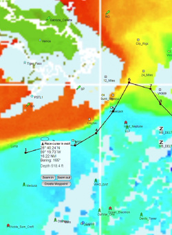
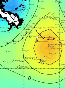
Moderate chlorophyll concentrations outperform both extremely low and extremely high levels for pelagic fishing because very dense blooms sometimes create conditions predators avoid. Tom Hilton explains interpreting color gradients from blues indicating barren water through greens and yellows showing productive zones, and why combining chlorophyll with temperature and current data identifies where complete food chains support apex predators.
WATCH NOW -
2024, Using Satellite Fishing Maps Before You Head Offshore
Satellite fishing maps give offshore anglers a real-time picture of ocean conditions before leaving the dock. Learning to read SST charts, chlorophyll data, altimetry, and current edges, and knowing how to layer them together, is one of the highest-leverage pre-trip skills a serious offshore angler can develop.
READ MORE