The vastness of the ocean appears as a seemingly endless expanse of blue, but beneath its surface hides a world teeming with life and activity. For countless generations, fishermen have relied on tales, experience, and intuition to interpret the hidden signs and signals of the sea. Today, with the power of technology, these oceanic secrets are revealed in greater detail, offering unprecedented insights into the marine ecosystem. By harnessing tools such as altimetry maps and the sea surface temperature chart (SST charts), fishermen now have a veritable key to the ocean's treasures.
The Magic of Ocean Upwelling
The phenomenon of upwelling is nature's way of invigorating the vast oceanic expanse. It is the process by which deeper, colder waters rich in nutrients are drawn to the surface. This process is instigated by winds that push surface waters away, especially along coastlines, making room for the nutrient-rich waters below to ascend.
The importance of upwelling cannot be overstated. It is the catalyst for a cascade of marine activity. The rising nutrients fuel the growth of phytoplankton, microscopic plants that form the base of the marine food chain. As these microorganisms multiply, they attract zooplankton, which in turn become a feast for larger fish like sardines and anchovies. This food chain culminates with the predatory giants of the sea, such as tuna and marlin, which are the ultimate goals for many fishermen.
However, the signs of this thriving marine life are not always apparent to the naked eye. Often, the only hint of an upwelling below is a slight drop in sea surface temperature. But thanks to satellite fishing maps and tools like altimetry, these
productive regions can be identified and studied in detail.
Altimetry - The Ocean's All-Seeing Eye
Altimetry offers a revolutionary perspective of the ocean's dynamics. By utilizing satellites to measure the sea's height from space, altimetry maps provide a detailed representation of the ocean's topography. These maps illuminate the highs and lows of the sea, the ebbs and flows of currents, and the locations of upwellings and eddies.
As nutrient-rich waters from the depths rise to the surface, they cause a subtle depression in the ocean's surface. Altimetry detects these depressions, marking them as areas of upwelling. These regions, often represented in shades of blue on altimetry maps, are crucial for fishermen. Not only do they indicate nutrient-rich waters, but they also serve as indicators of potential fishing hotspots.
Understand more about
altimetry charts and how to read them with our instructional video featuring
Thomas Hilton.
Where Two Worlds Collide - Upwelling Fronts
Fronts, or boundaries formed where different water masses meet, are teeming hubs of marine activity. These are areas where nutrient-dense waters from upwellings meet warmer waters from offshore. Such transitions create an explosion of marine life, making them hotspots for baitfish and, consequently, larger predatory fish.
Thanks to satellite altimetry and SST charts, fishermen can now pinpoint the locations of these fronts with greater accuracy. By combining the data from altimetry with the sea surface temperature chart, one can gain a comprehensive understanding of the underwater highways where fish congregate.
Learn how to read
satellite maps to improve your fishing.
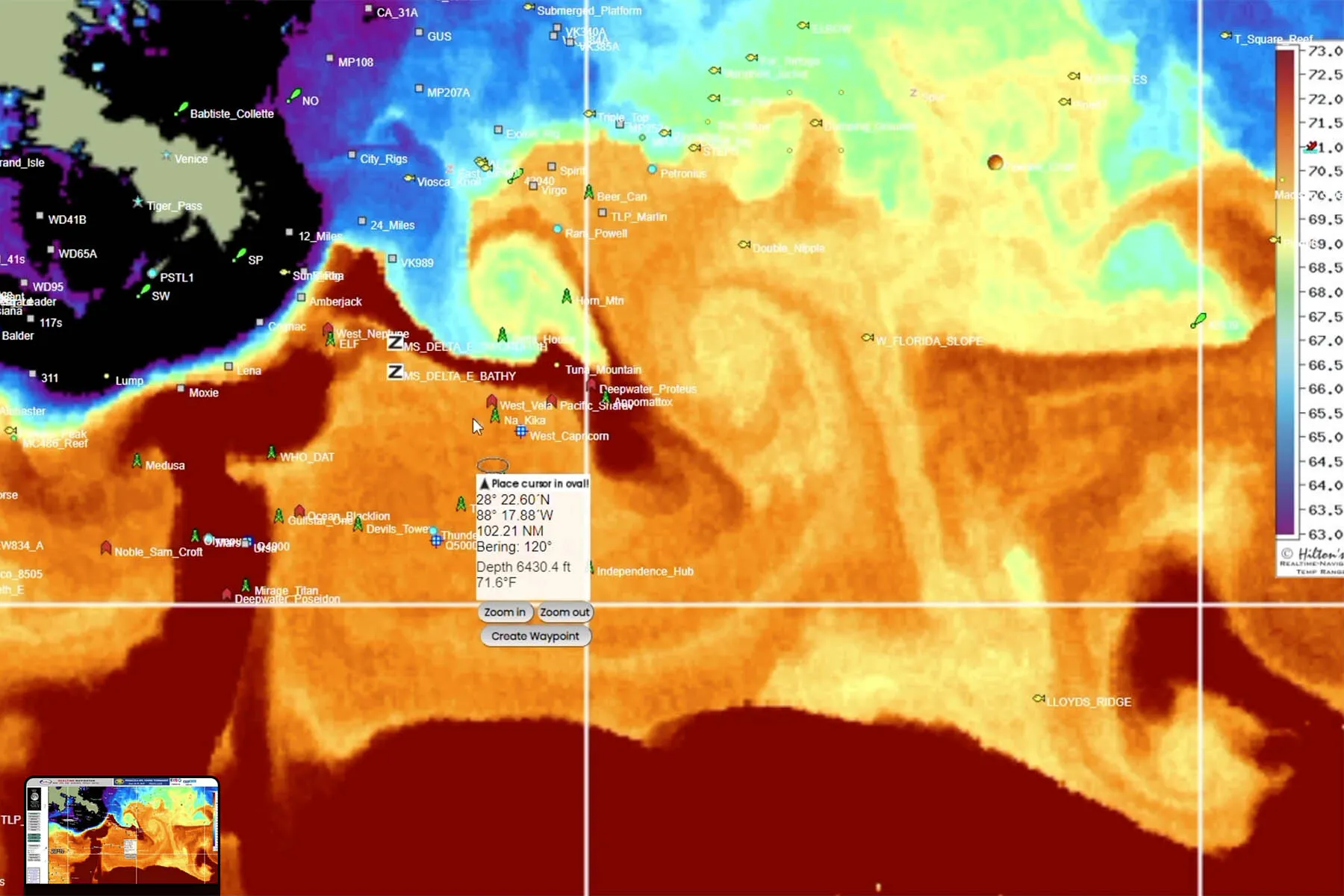
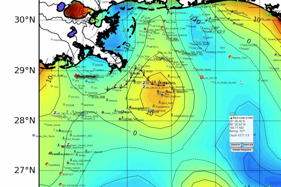
sea surface temperature map of the Gulf of Mexico
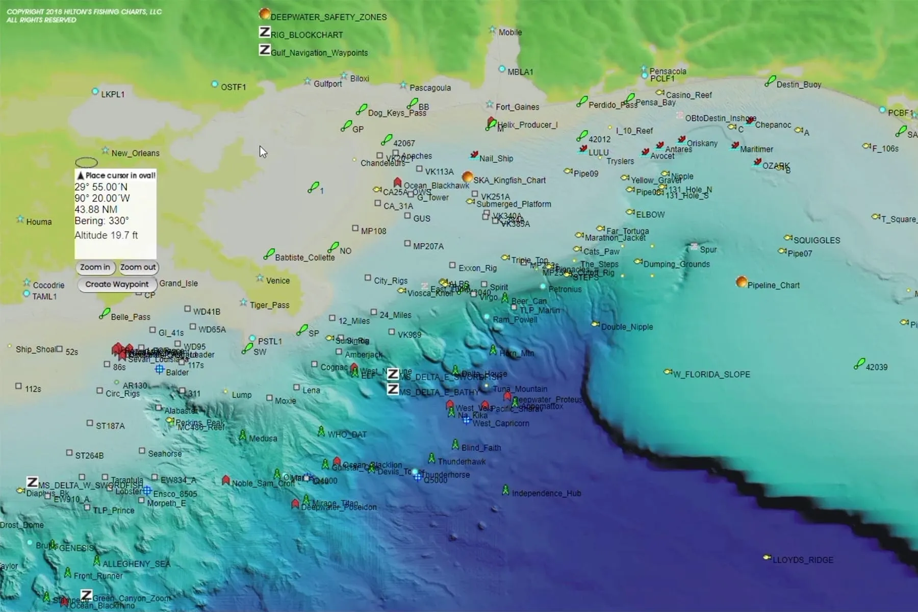
map showing bottom topography of the Gulf of Mexico south of Louisiana
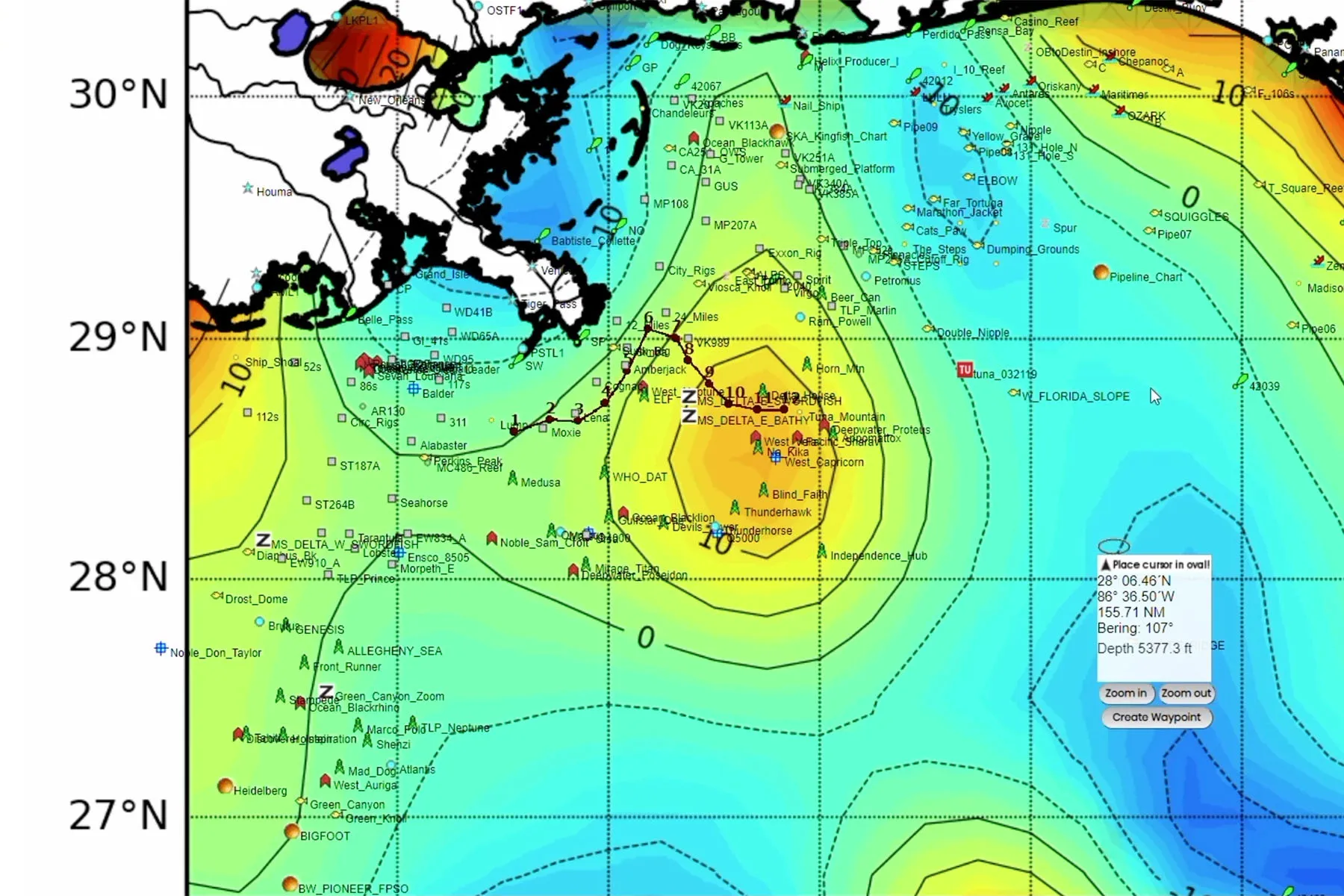
altimetry map showing fishing hotspots
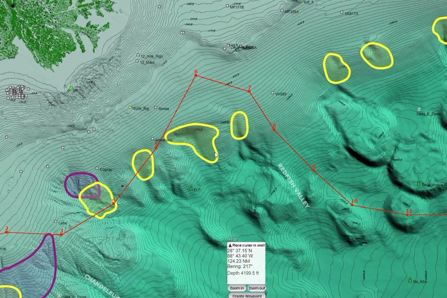
bottom contour of swordfish fishing hotpsots in the Gulf of Mexico
Where Technology Meets Tradition
While advanced tools have provided new insights into the ocean's dynamics, the knowledge passed down through generations of fishermen remains invaluable. This traditional wisdom, combined with modern technology, creates a potent mix for understanding and harnessing the sea's potential.
In various parts of the world, this blending of old and new has proven beneficial. For instance, in Hawaii, ancient Polynesian navigation techniques are being combined with modern altimetry data to identify fishing hotspots. Similarly, fishermen in the Arabian Sea use traditional indicators, such as specific cloud formations, to detect upwellings. When paired with satellite data, their success rates increase.
The Global Dance of Upwelling
While upwellings occur globally, certain regions serve as epicenters for this phenomenon. From the nutrient-rich Humboldt Current along the western coast of South America to the pulsating upwellings off California that attract large schools of sardines, these areas are vital for the marine ecosystem.
Additionally, factors like the
El Niño Southern Oscillation (ENSO) play a significant role in influencing upwellings, especially in the Pacific region. During El Niño events, weakened trade winds reduce upwelling, affecting marine productivity and fisheries. The intricate relationship between ENSO events and upwelling continues to intrigue and challenge researchers.
The Cutting Edge - Forecasting Upwelling and Fish Populations
The age of technology has brought about new possibilities for understanding the oceans. With advanced modeling and real-time data from satellites, scientists can now forecast upwelling events and their potential impacts on fisheries. By integrating various data sources, a holistic view of the ocean emerges, enabling better management and conservation strategies.
Upwelling Hotspots for Sport Fishing
While upwellings occur worldwide, there are certain regions that stand out for their productivity and popularity with sport fishermen. These dynamic marine ecosystems draw anglers from across the globe in search of trophy catches.
Gulf of Mexico
Upwelling plays an important role in the marine ecosystem of the Gulf of Mexico. Here are some key impacts of upwelling in this region:
- Brings deep, cold, nutrient-rich waters to the surface which stimulates phytoplankton growth. The increased phytoplankton supports the rest of the marine food web.
- Occurs seasonally, often during the summer months. The timing aligns with peak spawning periods for many commercially important fish species like grouper, snapper, and mackerel. The increased nutrients boost larval survival.
- Upwelled waters provide an influx of food for baitfish species such as menhaden. These baitfish congregate in large schools, attracting larger sport fish and predators. So upwelling facilitates sport fishing opportunities.
- The upwelling zones along ocean fronts are important foraging grounds for threatened sea turtles. The frontal boundaries concentrate both nutrients and prey like jellyfish and salps.
- Can impact red tide algal blooms. While upwelling introduces nutrients, it also disrupts and dilutes algal concentrations, potentially mitigating harmful blooms. However, the interaction between upwelling and red tides is complex.
- Upwelling induced hypoxia can occur if nutrient-rich waters cause excessive algal growth and decomposition. This can create oxygen minimum zones that displace fisheries. Proper management is needed to prevent severe hypoxia events.
- Since upwelling draws up deep ocean carbon dioxide, it impacts the carbon cycling and acidity of surface waters. This can influence coral and shellfish populations sensitive to acidification.
Upwelling is a crucial process in the Gulf that energizes the marine food web but must also be monitored for any extremes that can disrupt the ecosystem. Understanding this balance is key for researchers and fisheries managers in the region.
The main ocean current responsible for driving coastal upwelling in the Gulf of Mexico is
the Loop Current.
Loop Current
The Loop Current is a warm ocean current that flows northward into the Gulf, loops southeastward, and then exits through the Florida Straits to join the Gulf Stream.
- As the Loop Current flows through the Gulf, it creates eddies or spin-off vortices. Interactions between these eddies and the coastline induce upwelling.
- The upwelling occurs especially along the western and northern edges of the eddy systems as they impinge on the continental shelf. This brings deep, nutrient-rich waters to the surface.
- The upwelling zones stimulated by the Loop Current and its eddies tend to be more intermittent and variable compared to steady eastern boundary currents.
- But studies have identified recurrent upwelling regions, especially off the coasts of Louisiana, Mississippi, and Texas during summer months.
- The Loop Current moves seasonally, expanding farther north in summer. This northern expansion increases proximity to shelf regions and enhances upwelling.
- In addition to the Loop Current, seasonal wind patterns like southeasterly trade winds can contribute to localized upwelling in parts of the Gulf.
- However, research indicates the Loop Current eddies play the primary role in drawing nutrient-rich subsurface waters into the euphotic zone to stimulate biological productivity.
In summary, the dynamic Loop Current system is the key driver of major upwelling events in the Gulf of Mexico, providing an important influx of nutrients to the regional ecosystem each summer.
The California Current
The cold, nutrient-rich waters of
the California Current produce some of the most intense upwelling events in the world.
Stretching from British Columbia to Baja California, this eastern boundary current drives an extremely productive marine ecosystem.
As winds push surface waters offshore, deeper waters rise up along the coast, bringing with them aflux of nutrients. This fuels explosions of krill, anchovies, and other baitfish which in turn feed larger sport fish like albacore, yellowfin tuna, and bluefin tuna. During the summer months, sport fishing boats flock to hotspots like Point Conception and the Channel Islands to target these migratory tuna.
The periodic warming effects of El Niño can negatively impact upwelling. However, the overall reliability of upwelling in this region supports consistent trophy fishing.
Canary Current
The Canary Current runs along the northwest coast of Africa, bringing cold water southward from the North Atlantic. As these waters collide with trade winds along the African coast, intense upwelling occurs.
This fuels an oasis of marine life in the otherwise barren waters of the eastern Atlantic.
Large schools of sardines and other baitfish thrive in these upwelled waters. Larger pelagic fish like yellowfin tuna, blue marlin and sailfish follow the baitfish, providing incredible sport fishing opportunities. Popular destinations include Morocco, Western Sahara and Mauritania.
Humboldt Current
Stretching along the west coast of South America, the cold, nutrient-laden waters of the
Humboldt Current support one of the world's most productive marine ecosystems. As winds push offshore along the Peruvian and Chilean coasts, they drive major upwelling events.
These
upwelled waters support dense blooms of phytoplankton and huge populations of anchovies and sardines. These baitfish draw bigger predators like mahi mahi, yellowfin tuna, bluefin tuna, marlin and sailfish. Some of the best sport fishing in the world is found here, with anglers targeting tuna, marlin and other billfish.
The Future of Oceanic Discovery
As satellite and computing technologies continue to advance, our insights into the marine world will grow in clarity and detail. Already on the horizon are finer resolution altimetry sensors and even more advanced forecasting models. With these tools, upwelling dynamics and their impacts on fisheries can be predicted with greater accuracy.
Already, scientists are experimenting with advanced technologies like wave-gliders, autonomous ocean robots that can sample sea conditions continuously while transmitting data back via satellite. With improvements in artificial intelligence, ocean robots will be able to detect and analyze upwelling events and patterns autonomously.
The integration of ever more sophisticated data sources will provide a multidimensional perspective of the living ocean. This will equip researchers, conservationists and fishermen with the insights needed to study, manage and harness the ocean's bounty into the future.
Conclusion
The vast
oceans, once shrouded in mystery and folklore, are gradually revealing
their secrets.
Through tools like satellite altimetry and SST charts, we are gaining a clearer understanding of the marine world. As we continue to blend traditional knowledge with modern technology, we pave the way for sustainable and prosperous fishing practices. The dance of upwelling across the world's oceans drives an abundance of life, providing opportunity to anglers who learn to read the ocean's hidden signals. With the wisdom of yesterday and the technology of today, a bright future awaits on the open water.
Seth Horne
In The Spread | Founder, CEO & Chief Fishing Educator
