Start fishing better with FREE Weekly Video Tips delivered straight to your email.
hiltons offshore
-

2019, Hiltons Offshore Satellite Fishing Maps
Running offshore without calculating fuel burn to satellite-identified features versus closer alternatives wastes money on marginal trips. Thomas Hilton's integrated trip planner combines oceanographic data with weather forecasting and fuel consumption calculations, helping captains decide whether distant temperature breaks justify runs or intermediate zones provide better fishing per dollar spent.
WATCH NOW -
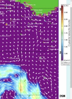
2024, Comparing Offshore Satellite Fishing Map Services
Five satellite fishing services compete for the same angler, but they are not selling the same thing. This breakdown covers what separates ROFFS, SiriusXM Marine, Hilton's Realtime Navigator, SatFish, and RipCharts on the variables that actually matter: update frequency, data layers, expert interpretation, offline access, and price.
READ MORE